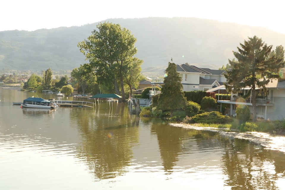
Rising water in Osoyoos Lake appears to have slowed down Thursday, as rivers feeding into the lake show shrinking water flow.
Officials told Osoyoos residents during a public information session Tuesday evening they expect to see the lake exceed the 1972 level of 917 feet, while remaining below the known record of 918.84 from 1894, as this week’s hot weather melts what remains of the high elevation snowpack.
Interesting update on #BCflood in #Osoyoos/Similkameen. First: Growth in Osoyoos Lake appears to have slowed down today. pic.twitter.com/YJg3kfAjrm
— Dustin Godfrey 📰 (@dustinrgodfrey) May 17, 2018
However, while Osoyoos Lake had begun growing in Wednesday after scraping the 916-foot mark, it began to slow down later in the day, continuing its tepid growth Thursday morning, reaching 916.27 feet.
Related: Osoyoos Lake expected to clear historic 917-foot mark
The Similkameen River peaks daily and comes back down as the flow is affected by daily melt feeding the freshet. Environment Canada's real-time hydrometric data show a diminished diurnal peak flow today. #BCflood pic.twitter.com/PyjuaUodjF
— Dustin Godfrey 📰 (@dustinrgodfrey) May 17, 2018
However, Environment Canada’s real-time hydrometric data show a diminished Similkameen River Thursday morning compared with the same time on Wednesday. The river runs in daily crests and troughs — the former the result of daytime heat melting mountain snow and the latter the result of cooler nights slowing the freshet.
For three days, that ebb and flow had been peaking higher each day, reaching about 600 cubic metres per second Wednesday morning, still about 30 m3/s below last week’s high. But Thursday morning, the river peaked at just over 560 m3/s before beginning to drop back down.
This graph hasn't been updated since yesterday (From B.C. River Forecast Centre), but it forecast yesterday's peak to continue growing, rather than follow the crest and trough gradual growth. Be interested to see today's update. #BCflood pic.twitter.com/znp4TRdyAM
— Dustin Godfrey 📰 (@dustinrgodfrey) May 17, 2018
The B.C. River Forecast Centre’s Wednesday morning update had anticipated that day’s peak would continue to rise, reaching the 10-year return period mark at 655 m3/s around midday Thursday. The forecast centre has not yet posted an updated forecast.
Related: Osoyoos hotel hopes to reopen early June after flooded by lake
Similarly, the Okanagan River near Oliver, after the dams that control flow from Vaseux, Skaha and Okanagan lakes, has diminished. 60% of the river flowing into Osoyoos Lake comes from tributaries below Okanagan Lake. #BCflood pic.twitter.com/7WcqhVHVEP
— Dustin Godfrey 📰 (@dustinrgodfrey) May 17, 2018
On top of the diminished return in the Similkameen, Environment Canada’s data for the Okanagan River near Oliver show a slowly retreating river. The flow in the Okanagan River steady much of the week in the 101 m3/s range before dipping to 100 m3/s on Wednesday and down to 99 on Thursday.
Officials say about 60 per cent of the Okanagan River’s water flow comes from tributaries flowing into the river below Okanagan Lake. And similar data from the Okanagan River after the McIntyre Dam show less of a dip in its flow than in Oliver.
Okanagan River Channel in #Penticton is showing shrinkage of about 1 cubic metre per second over last two days, compared with about 3 m3/s in the river down in Oliver. pic.twitter.com/thA8BoeulS
— Dustin Godfrey 📰 (@dustinrgodfrey) May 17, 2018
The Western News has put in a request for comment with the Regional District of Okanagan-Similkameen’s emergency operations centre, but has not yet received a response.